I’ve recently considered investing in some Geotagging equipment. But, besides the cost factor, I’m still not overly convinced about the general benefits for my photography of such capabilities. But first things first…
 What is Geotagging?
Geotagging is simply the process of including geographical information to the photographs, such as latitude and longitude coordinates, which is then kept as part of the EXIF information on the files.
How does Geotagging work?
Unfortunately, camera manufacturers are not keeping up with technology on this field. Either because including a GPS device would make the camera more expensive thus putting off some costumers or simply because geotagging is still not a mainstream requirement, the fact is that cameras with in-built GPS receivers are more the exception than the rule, although some high-end cameras are already equipped.
If you are fortunate enough to have opted for such a camera (probably you did it because of the other camera features and not because of the GPS) you don’t have to battle with yourself as I’m doing to figure if it’s really worth the investment. Just use it, you have nothing to loose.
If, on the other hand, your camera is devoid of a GPS receiver, there are several off-camera choices available and all of them are based on a very simple principle: time synchronization.
Basically, all you have to do is synchronize the clock on your camera with the clock on your GPS receiver (a one time process). Now, every time you turn on the receiver, it will record your position at defined intervals (15 seconds, 1 minute, etc.) and store this information on a flash memory card. When you are back at your computer to download your photos from the camera, just plug the receiver and the software compares the exact time at which a photo was taken with the closest time a geographical information was recorded and add the coordinates to the metadata of the photo file. Very simple.
What are the benefits of Geotagging?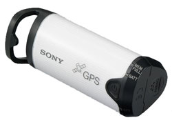
From a “photography as art” point-of-view, the benefits of Geotagging are virtually non-existent. It will not improve your photos per se.
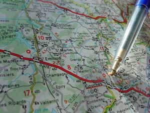
Geotagging is more an organizational tool than anything else. It will allow you to see on a map the exact location where a photo was taken. It will also allow you (and others if you share your photos online) to search for photos taken on or nearby a specific location. Although on a short time scale it will probably be very “boring” to see your photos just concentrated on a very small portion of the map, if you tend to photowalk a lot and do some traveling, the range will broaden and it will become much more interesting to have a large scale view of where all your photos were shot. Back to photowalking, it can be fun to be able to track your route on a specific date and it will probably improve the plan for future photowalking tours. Besides the software that comes with whatever receiver you acquire, there is a multitude of software available that allows for interaction with either Yahoo! Maps or Google Maps and Google Earth.
If you are into photography sharing networks, since August 2006 Flickr also supports geotags and, together with Yahoo! Maps, can display the locations of your photos. Same goes for other networks like Zooomr.
As an added benefit, yesterday (Nov 28), Google launched a new layer to the Google Maps – the Google Terrain – which gives a more 3D view of the existent maps and can, together with your geotags, provide a more spacial arrangement to what your surroundings were when a photo was taken.
Limitations of Geotagging
Although I’ve almost managed to convince myself to go for a GPS receiver, there are still some limitations to the technology that I’d like to see addressed.
First, any external GPS receiver is an extra thing that you have to carry around. Ok, it’s not big, it’s not heavy. But it’s an extra thing. With an already cluttered camera bag, any extras will need to be evaluated to see how worth it they are.
It’s not cheap. Ok, it’s also not expensive. For something like $100 to $150 you can get a receiver specially designed for photography geotagging. Nonetheless, for that amount, you can always get an extra battery or an extra memory card or start thinking about your next lens. When the budget is tight, even the smallest amount of money available to invest in photography needs to be well thought.
Battery limitations. A normal AA battery on such a device will give you something between 10 to 20 hours of continuous use. Although this is more than enough for a normal photowalking tour, if you go on vacations on a place where normal batteries might not be readily available, it is another something to have to think about.
Precision. Although most GPS receivers are very precise, they are not perfect. There will be always a percentage of your tags that will be “off the mark”. For the more common (and cheap) GPS receivers specially designed for photography, there are some complains about how precise the device is.
Photographer or Object. This is a big one if you are a perfectionist. The receiver is with you, so the tag will be your location and not the object of your photo’s location. Can’t do much about it except manually editing the tags. I don’t see myself having a problem with this one, but for some applications it can arise as an extra complication.
Bearing. Another of those things that you can’t do anything about, but would be nice to see implemented, specially if you are much into landscape photography. With such high-tech features such as image stabilization that works by countering the movement of the camera and adjusting the sensor, it would be nice and not hard at all if metadata would also include a bearing and tilt angle. Together with focal length (which is already recorded) and coordinates, it would be possible, on a map application, to “see” exactly the photographed area. Too geeky?
Overall
Overall I think that Geotagging has a true potential to improve the photographer’s experience. It has some limitations, but every technology has them. Nonetheless, at this moment, I still am not completely convinced that a GPS receiver simply for the ability to add coordinates to the metadata is the best choice for my money.
Can you help me on this one? Do you think it is worth it? Do you have experience with automatic geotagging? Share your thoughts with us… any help is appreciated.
Pingback: photographyVoter.com
Cyron
November 30, 2007 at 2:03 pm
I have some experience with GPS based geotagging.
Like you, I avoided doing it initially partially because of the “one extra thing to carry” issue. Eventually though I settled on a phone with integrated GPS to get around that issue. Of course the phone has issues with battery life (about 4 hours of continuous track log recording), but it can be recharged using a car kit, so if you’ve got access to a vehicle, it’s not a show stopper of a problem
There are two main benefits I get from it. One is the social photography aspect, from sites like flickr. The ability to view geotagged photos of various places around the country is fantastic, and I enjoy being able to add my own experiences to that.
Secondly though, you can do many cool things with google earth and google maps with tracklogs and photos, and the ability to “replay” a photo trip, or show it to some friends is something I really enjoy.
Sure, none of it improves my photography, but it sure does improve the enjoyment I get /from/ my photography
Pingback: Words: Irrational » Still on Geotagging
Pingback: Link Roundup 12-01-2007
Pingback: Saturday Links Fever [2007-12-01] at All Day I Dream About Photography
Claudius Coenen
December 2, 2007 at 3:59 pm
You’re perfectly right when saying that geotagging is boring for the short timescale.
I started geotagging roughly a year ago with the sony gps cs1 and the extra work is driving me nuts, but now that i really traveled a little with this device it starts to pay off.
<a href=”http://amenthes.de/index.php/2006/10/urlaub-von-oben/”These are image overlays on of my first vacation with GPS.
Since then i used it in sweden and the us. I also started tagging images by hand in case i didn’t bring the GPS-Receiver.
Pingback: ATP Photofinder Mini - Reinventing Geotagging (Product Review) | Words: Irrational
Pingback: PhotoNetCast #17 - Geotagging with the Photofinder Mini | PhotoNetCast
Vince Hindman
September 26, 2009 at 6:42 pm
One other issue you didn’t address is dropouts. Most GPS receivers have difficulty tracking a location if the receiver is inside of your camera bag, coat pocket, or under heavy foliage. Newer recievers have much better performance in these conditions but with current technology this is still an issue. Other receivers with cell phone assist capabilities will do very well if cell towers are within range but how often is that the case? Another problem is the length of time it takes a receiver to generate a fix after first being powered on. Typically these times are 45 seconds or greater. GPS receivers also do not work well indoors. The other problem for camera manufacturers is how to place a decent GPS antenna on the top of a camera that is already crowded for space. I suspect that most solutions going forward will be external devices that attach to the hot shoe flash.